Chapter 4
Stations and Geographies
Station Areas
The TOD Database currently has 4,416 existing stations in 40 metropolitan regions and 1,583 planned and potential stations in 44 regions, 14 of which have no existing stations. These numbers are current as of October 2011.
The existing station list and geographic locations were originally derived from the Federal Transit Administration’s National Transit Database, and updated where appropriate. Fixed-route transit systems included are heavy rail, light rail, commuter rail, streetcars, bus rapid transit (with dedicated right of way) and cable cars. The database also includes some Amtrak stations that serve commuters.
Transit stations are broken down into selected categories.
Existing Stations
- Commuter Rail Most existing commuter rail stations were originally digitized from the FTA’s National Transit Database GIS file in 2004. In some cases, CTOD employed GIS data from transit agencies and municipal GIS departments. Where available, all existing stations were updated in 2011 with General Transit Feed Specification (GTFS) data.
CTOD tracks both attribute and locations changes over time and records. Stations and systems that have closed due to low ridership are maintained in a separate database file for potential analysis.
Multi-modal transport is also included in the database as these stations play a vital role in commuter transport systems. Examples of these stations include the Aerial tram in Portland, OR and commuter ferries in Seattle and San Francisco.
- Commuter Amtrak In some areas of the country, Amtrak serves as a commuter rail service, and these stations are included in the TOD Database. This is particularly true in the northeastern corridor where the Amtrak Downeaster service connects the Maine coastal communities with employment opportunities in the Boston Metropolitan Area. Another example is the New York City commute shed which extends to Poughkeepsie, Rhinecliff, Hudson and in some cases, into Albany. The following Amtrak lines (partial and complete routes) are currently in the database: Acela, Ethan Allen Express, Keystone, Downeaster, Hiawatha, Cascade, Capitol Corridor, and the Pacific Surfliner.
Planned Stations
- FTA New Starts CTOD refers to the FTA Annual Report on Funding Recommendations for New Starts each fiscal year for its list of potential FTA-funded transit projects. Projects are included under potential stations if they are in the Preliminary Engineering phase or beyond of the funding timeline. A number of Bus Rapid Transit (BRT) projects have entered the New Starts funding process. BRT projects are included in the Database where a dedicated right of way is included in the project description.
With each update to the database, New Starts projects that have been built and are in operation are moved to the existing station file and New Starts projects that have progressed to a new phase in the funding timeline are tracked.
- Urban Circulator or TIGER 1&2 recipients that are fixed guideway.
- Projects funded with other federal sources including TIFA loans.
- Non-FTA funded locally-funded projects that are under construction. An increasing number of metropolitan regions are developing rail transit proposals outside of the FTA funding process. Many of these projects are funded through local sales tax revenue and local referendums.
Proposed
- FTA New Starts that are in the Project Development phase of the funding timeline.
- Non-FTA funded locally-funded projects that are far enough in the local planning process that station locations have been determined.
- Closed stations are removed from the existing station file but kept for future research.
Station Geography
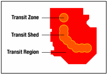
Data is aggregated to three different geographies:

- Transit Zone is the half mile buffer around each transit station. One half mile (radius) is widely considered a walkable distance to travel to a fixed guideway transit station. The Database allows the user to query transit zones for existing stations, potential stations, and both in tandem. Data can also be aggregated to the quarter mile buffer for research related to the immediate station area.
- Transit Shed is the aggregate of transit zones and can be calculated for selected stations, an entire line, an entire agency, or the transit region. An important feature of the transit shed statistics is that when two transit zones overlap the transit shed does not double count the data. The transit shed is available for both existing and potential stations, and a combination of the two.
- Transit Regions are aggregated from one or more Census County boundaries that contain the majority of the region’s transit system. Using counties allows for more consistency when aggregating data with different geographical bases (e.g. TIGER 2000, TIGER 2009, TIGER 2010, etc.).
