Chapter 8
Download Data and Stations
Chapters 6 and 7 reviewed how to create standard and custom reports using the TOD Database; the following are instructions for downloading the data compiled in these reports.
Click on the Full Report tab on the Report menu bar.

This expands the Report section and compresses the map; the Report defaults to a list format. In the full report view, the Report menu still allows the user to change the data displayed and the geography. Additionally there is the option to change the format that the report is viewed in and to download the data.

In the table view, the map is removed.
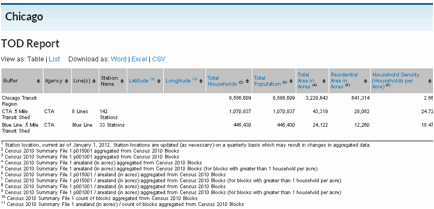
The table columns can be sorted using the arrows next to the column heading.
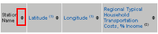
Next to the column heading in both the list and table report views is a footnote number. The footnotes indicate which data source the information in the column is from; footnotes remain when the data is downloaded.
Downloads only include data, not the map. However, users can print without downloading to get both the map and the data. Open up the print preview window, adjust the page setup as desired and print.
To return to a larger map, click the Close Report button on the Report Menu.
Downloading Station Locations

The Full Report view includes the latitude and longitude for all selected stations. All stations in a region can be downloaded by clicking on Station Downloads at the top of the window.
This will open a new tab with a list of all the regions. Users can choose to download all the stations in the US or only stations in a specific region. Stations are downloaded as a CSV file and only basic attribute information is included: station name, line, project type, and latitude/longitude.