Chapter 9
Case Studies
Regional Snapshot of the Delaware Valley
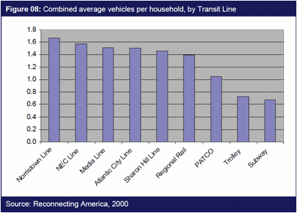
In 2008, the Delaware Valley Regional Planning Commission (DVRPC), the regional land use and transportation planning agency for the Philadelphia-Camden-Trenton metro area, combined data from the TOD database with local ridership data to create a snapshot of every transit zone in its system. Using several metrics, including population, race, owner-renter housing mix, journey-to-work, household income and auto-ownership, DVRPC identified the highest and lowest transit zones for each category. DVRPC also used these metrics to compare the various transit lines in its system, including trolley, subway and several commuter and regional rail lines. The report was followed by an appendix with raw data for all metrics for each station in the system.
Intended as a baseline for further analysis of station areas and TOD opportunities in the Delaware Valley, the report pointed towards several key questions and issues including auto-dependency within transit accessible areas, and varying levels of car ownership in areas with access to different transit modes. The chart reproduced below indicates the great range in car ownership rates across the region’s transit lines, demonstrating that transit corridors with the lowest car ownership also tend to be more centrally located, with higher densities and a mix of uses.
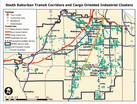
TOD Selector Analysis in Chicago’s South Suburbs
In 2009, the Center for Neighborhood Technology (CNT) produced an analysis of baseline conditions and TOD opportunities around 33 station areas in Chicago’s south suburbs using data available on the TOD database. The report, Making Smart Choices: Transit-Oriented Development Selector Analysis of South Suburban Corridors¸ considered 38 variables, including census-derived measures of household density, aggregate income, and journey-to-work, as well as local metrics, to gauge TOD potential in each community. Based on their scores, station areas were categorized into three TOD types representing suitability for varying levels of density and development.
The types used in the analysis were: Town Center TODs, similar to a main street district of a relatively large suburban town with frequent transit service, relatively high density and mix of residential and commercial uses; Community Area TODs, commercial service centers for a neighborhood or village of a few thousand residents, with moderate residential density and a cluster of convenience goods and service businesses; and Residential TODs, places consisting almost completely of residential development. A category was also included for undeveloped station areas, which applied to stations surrounded by vacant or under-developed property.
Until this report, individual municipalities had prepared TOD plans for their station areas without taking into consideration the plans of neighboring towns. Smart Choices led the Regional Transportation Authority of northeastern Illinois to award a subregional planning grant to the South Suburban Mayors and Mangers Association (SSMMA) for the preparation of more detailed implementation plans for potential projects in the south suburbs. The results of the analysis also led SSMMA to form a consortium of suburbs interested in targeting federal NSP and EECBG funds to transit nodes along the three Metra corridors there.
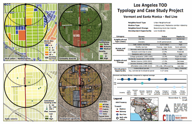
TOD Typology and Station Profiles in Los Angeles
The Center for Transit Oriented Development (CTOD) has used the TOD database to perform analyses and create typologies for station areas around the country, including corridors in Denver, Houston and Baltimore. Most recently, CTOD completed a data-rich analysis of all 71 existing and planned rail stations in Los Angeles for the city planning department with funding from the California Department of Transportation and assistance from the Los Angeles County Metro. For this project, stations were organized into place types based on their intensity (residents and workers in the half mile radius around stations) and mix of land uses.
This analysis has yielded a wealth of information about the mix of land uses and underutilized property in the half-mile radius around stations; the households who live in these neighborhoods and their travel behavior; changes in income and education; and vehicle miles traveled and transportation-related greenhouse gas emissions. The performance of each station can be assessed relative to other stations, providing a focused analysis of strategies that can be employed to increase ridership or walking and biking, for example.
Most importantly, the typology can be used to help local governments as well as the private-sector and community stakeholders understand which stations should be prioritized for development, or for investments in affordable housing or bike and pedestrian infrastructure. The work in Los Angeles found, for example, that there is relatively little land available for development near stations. This means that TOD in Los Angeles may be as much about improving bike and pedestrian access to stations and ensuring that there’s a good mix of uses, as it is about actual development at the station. The profiles completed for each station area can be used to help identify:
- The most appropriate strategies to reduce auto dependence, whether this entails development, improving the mix of uses, investment in affordable housing, or investment in bike and pedestrian access, for example.
- Whether the station has so much development potential that it should be prioritized for public and private investments.
- Whether there is an immediate threat of gentrification, and whether federal contracts for subsidized housing are expiring.
Among the conclusions of the LA report is that TOD requires the cooperation and collaboration of different departments and agencies that can together co-leverage the resources required to create high-performing neighborhoods where people don’t have to drive. The report, data and analytical tools were enthusiastically received by the project Steering Committee, which includes city staff and representatives of other agencies, as well as developers and community groups.